I just came across this link to a digital copy of T Alldrige’s book on Sherbro and Hinterland: https://archive.org/details/sherbroanditshi00alldgoog/page/n10
And his later book written in 1910: A Transformed Colony
Enjoy!
I just came across this link to a digital copy of T Alldrige’s book on Sherbro and Hinterland: https://archive.org/details/sherbroanditshi00alldgoog/page/n10
And his later book written in 1910: A Transformed Colony
Enjoy!
If you have been following this blog and would like to hear about my new home, Uganda, please sign up here
It has been sometime since I last updated this blog. This is because my time in Salone has sadly come to an end. I very much enjoyed exploring this beautiful country and will miss the lovely people I met there. My next adventure will be in Uganda and I will endeavour to keep a blog there too, so will post a link here when I start it, so anyone interested can follow me.
In the meantime I thought I should make this post an index of past posts to make this site easy to navigate. Click on the brown names to reach the relevant blog:
History
Why is Sierra Leone so called?
My great-grandfather in Sierra Leone
The Connaught Hospital and environs
Bunce Island and Slavery
Delphine Reynolds pioneer aviator
Travels
Chimpanzee sanctuary at Tacugama
Interesting projects
Dignity market disabled project
There are other blogs about flowers, walking the beaches and the seasons which can be found by the search box or Past posts.
I hope readers have found this entertaining and informative and look forward to exploring Uganda with you!
The rainy season is with us. A couple of weeks ago we were enjoying the clear air and bright colours of the landscape washed clean and made lush by early showers. The colours are still bright and the landscape lush in between the torrential rain and the occasional ray of sunshine. Newly tarmacked roads are strewn with mud, stones and debris washed down from intersecting dirt tracks. It’s no one’s job to clean them up, so they will just get muddier and stonier. Potholes on older roads are getting bigger and deeper and ominously filled with muddy water.


Taking an umbrella everywhere is wise, but I have yet to master the art of getting into a car and collapsing an umbrella in a smooth operation which doesn’t negate the use of said umbrella; in those few seconds of collapse in torrential rain you still get very wet. Local guards and motorbike riders sport a variety of rain gear – quite a few sets of Personal Protection Equipment (PPEs) from ebola times have been seen around. Footwear is not a problem so long as it is washable or very waterproof.
Not expecting much respite until September, which will be after we leave Sierra Leone at the end of this month.
A leisurely 2 hour walk took us from the Guma Dam down to the Peninsula Road. You need to get permission to drive into the Guma Valley Dam area before arriving at the gate and, unless you want to return uphill, arrange for a vehicle to meet you at the bottom. The walk can equally be done from the bottom up (returning the same way), in which case, no permission is needed, so long as you don’t go over the dam. The dam is over 2 miles (3.5km) up a narrow track from the entrance gate, reached from a turning off the Peninsula Road before Sussex.

")
The dam and water works date from the early 60s and are still the main source of water for Freetown. The pipe follows the Peninsula Road along the coast to the city. There is a holding reservoir at Wilberforce where tankers are filled for distribution. Very few houses in Freetown are, or ever have been, connected directly to a water supply. Most properties have water tanks which are filled periodically by bowsers, others make the daily trek to the nearest tap or pump with their plastic jerry cans.
A well appointed roundel shelters picnic tables, while others nestle under lakeside trees. However we were not sure who uses them, given the area is not open to the public, apart from a few locals harvesting mangoes from the trees beside the car park.


The lake, created by the damming of the No.2 river, is very pretty – now at its lowest level as it is the end of the dry season, but the rains should arrive soon to replenish the supply.

The white paintwork looked newly done and very smart.
The spillway is also waiting for the rains.


The path crosses the dam, through the gates, making sure you see the instruction not to open without a pass!


The view down the valley gives an idea of how high we were – the road to Tokeh a faint red line in the middle distance.

The path then enters the forest and is a well defined track as it passes a couple of buildings then starts uphill. Shortly after this, we branched off to the right – not entirely obvious but the path is marked by small red ribbons as you progress. This stretch is a forest track, narrow and winding round trees, so we were glad of the guide. However, after sometime, a few scrambles and changes of direction we moved on to a very well defined track which later became a road – albeit 4WD and in bad repair. It was obviously built for vehicle traffic, but the lack of bridge bed over one of many streams would prevent vehicles using it now.


The forest was peaceful, with only a few bird calls to disturb the quiet. Despite being towards the end of the dry season the foliage was lush, although in parts the path was covered in a deep layer of dry leaves – just like autumn at home, kicking through leaves! Some trees drop their leaves to conserve water until the rains come. There are some surviving large trees, one with particularly red ragged bark was tall and straight, but botanical skills lacking, I could not identify it. Several others with smooth grey bark had spectacular buttresses and root systems. Unfortunately no wildlife to speak of except a variety of butterflies around each stream.


It was a lovely surprise to come across an area where the trees had been thinned and we could see across to the coast and our destination at No.2 River (such an imaginative name!) and, top right, through the trees Tokeh village. The dirt areas are where the road is being improved – from a very bumpy track to a dual carriageway!
From this point it was downhill all the way. Just beside the last stream we crossed we noticed a pipe inserted in the stream, then buried roughly beside the path. We found the reason why, a little way on.

This is the ranger station with a stream fed water tank to service the facilities – another surprise; this is the only place in Sierra Leone I have ever seen a notice like this: ‘Toilet’!! Definitely worth a picture! But none of us actually tried it out.
Not far beyond this we came to the junction with the road which is quite clear on Google Maps. It is then a dusty 2km along the road to the coast.

It should be quite possible to follow this trail from the road end. The higher part might not be entirely obvious, but look for the red ribbons. When you reach the track at the top, turn right for the waterfall – a little further uphill – and then return by same route. There is room to leave vehicles at the start of the track.

The Turtle Islands lie tantalisingly close to Sherbro Island, but are a world away from mainland Sierra Leone and certainly seem that far when trying to visit.
")


Having arrived in Bonthe [see previous posts about Bonthe and the journey there], we discussed the trip to the Turtle Islands with the boat driver to determine how long it would actually take, having heard several different estimates. We were assured that if we left early (7am) the tide would be right to reach the islands in about an hour an a half. We would have to wait there an hour or so for the tide to ebb, then we could return in similar time. So we agreed and set our alarm clocks.
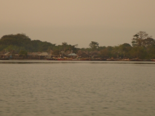 We departed just after dawn broke with the rising sun reflected by the glassy water. Our boat created a white wake as we sped past sleepy settlements on the low lying shoreline. Small groups of houses appeared, preceded by the sight of tall trees above the normal height of the mangroves. In some places we could just see a dark entrance way into the mangroves, wide enough for canoes, but the settlement remained hidden by the foliage.
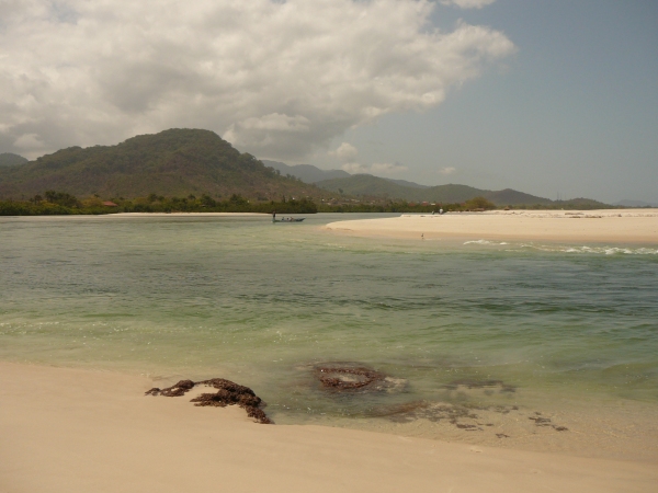
After the predicted time, our first view of the islands as they emerged on the horizon.


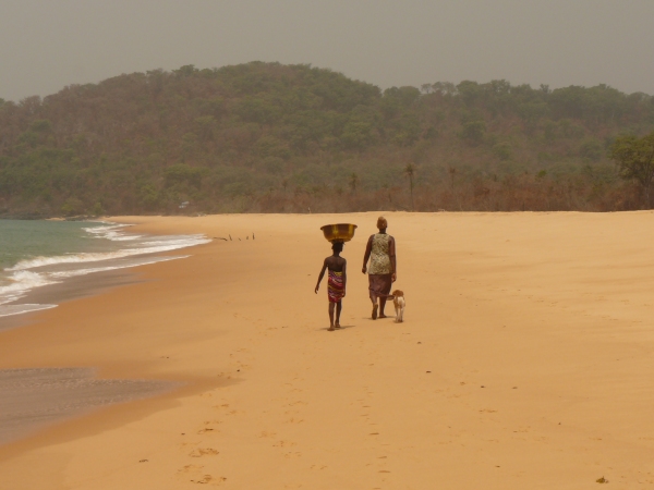
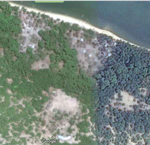
This is the tiny sand bar known as Nyangei, which is an incredibly high-density settlement on a narrow slither of sand, shown as N on the satellite image below and in close-up. There are over 80 houses on this tiny island. We approached from the north and first tried to go past the west side but were prevented by the emerging football field. We could see the goalposts sitting in the sea off the bottom left corner of the sand, but within half an hour it would be a dry pitch, so we had to retrace our route to avoid being marooned, and passed the other side of the island.


Our first stop was on Bakie – lower centre of the image above [click on it to magnify]. At least half the population came to greet us on the beach and the head man showed the community the cash gift we gave him, before pocketing it for safe keeping. After a refreshing coconut picked for us from a nearby tree, we walked around the island, guided by adults but followed by a posse of children; those with shoes having the advantage, while those without ran from shady spot to shady spot to avoid burning their soles.

Almost all the huts were built from natural materials, with a stick frame filled in with mud from the inside and a thatched roof. Dotted around were small, roofed structures with ladders for access by poultry (centre of photo). Further back in the village were smoke-filled huts where the daily catch is preserved before being transporting to the mainland. The art (or science?) of smoking has been lost in some parts of the country and there have been instances of fish rotting when not correctly smoked.

Shell debris littered the whole area showing how important a resource this is – we later saw a large pile of dried cockles, also ready for trading.
Following the school teacher, we went to see the primary school (photo below) which serves about 100 children; a blackboard on each side so two classes run at once. The older children have to go to Bonthe or the mainland for further schooling. This is a community school not supported by the government.

Having finished the village tour we were shown the Bakie Guest house which is marked on Google Maps and described in the Bradt Guide, but sadly is no longer habitable; the roof was removed by a storm and the building now looks decidedly dilapidated.


We walked from the guest house south along the beach to the end of the sand and unfortunately found ourselves separated from a further beach by a swampy inlet. Later it was passable and the whole coastal stretch around to the Atlantic was available.
It was then time to wait for the tide to flow out, before we could make our return journey, so we sat under a palm tree and relaxed as the villagers went about their business, cooking, playing, hairdressing, mending nets and sitting chatting. On a second pass a long the beach with the vague idea of having a swim, we realised that the stretch of sand just outside the village was in fact also the local toilet, so we passed on quickly and only paddled much further down. The water was not inviting as it shelved slowly and was not well tide washed. It appeared muddy and stirred up easily, so that, and the jelly fish beyond, kept us in the shallows.

Once the tide was deemed right, we said our farewells and set sail across the bay to the next island of Yele where we went through the same routine; greeting the head man (with cash), touring the village, visiting the school and being shadowed by dozens of children.
The settlement on Yele was slightly larger than Baki and had more concrete houses, plus a substantial school building (built a few years ago with help from the Bonthe council); the shiny roof at the bottom of the image.
The soil on these islands is mostly sand and very little grows apart from scrubby vegetation, some fruit trees and plenty of mangroves. In the villages a few people had small vegetable patches, fenced to protect them. The villagers seem to rely heavily on the sea to provide what they need and trade with Bonthe and the mainland for what they lack. It is a remote existence, certainly far from the madding crowd. I am sure if you slung your hammock or pitched your tent, you could spend a night under a canopy of stars away from the frenzy of modern life, but we preferred to return to a comfortable bed.
Most of the boats traversing the area between the islands were powered by poles punted through the shallow waters. It was these shallows, which you see a hint of in the satellite images, which slowed our return journey, the boat having to aim for the deeper parts and creep over the shallowest. Once out into the main river, progress was faster, but it took a good deal longer coming back, not helped by having to conserve fuel until another boat could rendez-vous with us to bring further supplies of diesel.
We had made our trip to the Turtle Islands. We didn’t see any turtles, but had not expected to. Several species are seen hereabouts and nest on these southern beaches. The remote location should be reasonable protection for their breeding sites. They are legally protected in these waters, but with little enforcement, whether the ban on killing them or poaching eggs is effective or not, who knows?
Was the trip worth it? On balance, yes, it was interesting to see these remote islands, which seem to float like bubbles from the tip of Sherbro Island, and the people who inhabit them. So long as your expectations are low, you will not be disappointed.


My enthusiasm for sharing my impressions of Bonthe meant I wrote the last blog before this one, which explains how we arrived there. So, apologies if you are at all confused!
We never really intended to go to Bonthe, but are glad we did. The real aim was the Turtle Islands (TI on map above), but my propensity for motion sickness had put me off this trip. Most travellers arrive on the Turtle Islands by boat from the Banana Islands, with estimates of the time involved ranging from an optimistic ‘around 3 hours’ (in a speedboat with a following wind and favourable tide) to the actuality experienced by many of 7-8 hours in an open boat (no shade) with optional marooning on sandbanks depending on tide. None of the tales I had heard filled me with the enthusiasm to say ‘let’s go!’. Additionally, on arrival on the islands, the only option for overnight accommodation is to camp, having taken all your supplies with you.
Back to the drawing board. We were then advised the best way to get there is to go to Bonthe, stay there, and take a speed boat to the Turtle Islands for the day – an hour and a half to 3 hours each way, depending who you spoke to.


So we settled on this route and drove to Yagoi, where the speed boat would meet us for transfer to Bonthe. The route is very easy, we were told, go to Moyamba Junction, then take the road for Rutile (Sierra Rutile Company) and just go straight!
We passed the large settlement where the workforce live in the hills before the rutile extraction area which was flat with turquoise lakes.


The route wasn’t quite so straight forward as described, not helped by a few signposts which appeared misplaced, but really depended on how you approached them! We arrived in Yagoi in good time. The Maritime Safety office (hut) was very concerned to record our names to ensure our safety on the water. Though there didn’t seem to be a system for recording our return.
")
")
These photographs were taken on our return and look as tranquil as it was. However, our outward journey was a little more lively! I was carried on board and sat behind the driver, whilst the others clambered on board. I wondered how old I looked! We set off along the river, which soon widened and the wind picked up. First a little spray whipped off the waves and I had a refreshing shower, then the breeze increased and buckets of spray headed my way. The driver suddenly noticed, slowed down and suggested I move up front where my companions were blissfully dry. We set off again and this time the wind whipped waves, enhanced by the tide, began to get higher, causing the boat to rise and fall with waves crashing over the stern and all down my back, to complement my wet front! It was, thankfully, not a long ride.
As the river widened we passed areas of rice cultivation along the banks and plenty of mangroves. Some pelicans had found some isolated plants for their nests. It is remarkable how quickly the low shoreline is reduced to a thin line on the horizon (these photos were also taken on the return journey!).
")


We passed York Island which was once a base for the Royal Africa Company during the 18th century, exporting camwood, ivory and slaves. In 1880s it became the headquarters of Patterson Zochonis trading company (now PZ Cussons of Imperial Soap fame); their abandoned warehouse remains in Bonthe.


Rounding York Island, Bonthe came into view, and we landed beside the Bonthe Holiday Resort where we were to spend the next two nights in comfort.


")
The bougainvillea along the fence was the prettiest on the island. The paths between buildings were made of cockle shells (not to be tackled in bare feet!) but remarkably effective; being hard wearing and visible at night as they shine in the moonlight. They are also noisy to walk on, so you have warning of visitors!
The resort primarily caters for deep sea fishermen who fly in to grapple with tarpon, a game fish found in these waters. We were the only guests. There are a number of round buildings, named after fish, each with two or three bedrooms, ensuite, and a shared living area. Meals are served in the restaurant block.
Before sunset we wandered around the town, becoming acquainted with its unique ambiance; for more details see my blog Bygone Bonthe. The Turtle Islands beckoned, but that was for another day.


It is tempting to say that arriving in Bonthe is like stepping back in time, there are few motorised vehicles on the island (we saw one working tractor and a couple of motorcycles), so the pace of life is slowed to a stroll. However if we had stepped back in time in Bonthe, a hundred years ago, or even sixty, we would have found a bustling, thriving, trading centre which is far from the reality today. As Thomas Aldridge observed in 1910; “In the stores of the European firms, in the stores of the Creole traders and of the Syrians, outside the stores, on the roadside pitches, hawkers, pedlars, and itinerating hucksters all vie in their respective ways with one another. There is selling over the big counter, over the small counter, off the strap tray, out of calabashes carried on the heads of the little pickins [sic: children] and even from off the ground itself – all is trade, nothing that brings in ‘cash monies’ comes amiss.” The bustle this suggests is long gone. The remains of its heyday litter the waterfront; decaying warehouses, a broken seawall and abandoned houses.


")
Compare these photographs with those below taken in 1958, by which time the river had silted up and ships were no longer able to anchor off Bonthe or York Island. Instead launches took cargoes of palm kernels, groundnuts and pissava [dried palm stalks used for brush bristles] out to ships tied up 5 miles downstream. But it was still a lively settlement with a resident District Commissioner.


The ruin above centre is the large building seen behind the jetty. The building on the left is the local court. Just behind it is the jail, surrounded, as is customary, with razor wire topped walls, but as we walked around town on our first evening, our guide indicated three men who had just passed us with a friendly greeting and told us they were the prisoners returning to jail. On further questioning he explained that they were let out each morning and they went to work for someone, returning, by themselves, in the evening. He told us that prisoners applied to be transferred to Bonthe jail from the mainland because they know they will be allowed out during the day. The crime of one of the prisoners was to have stolen one of the solar powered street lights – not the most intelligent crime on a small island; we wondered who he thought he might sell it to?? The RUF leader Foday Sankoh was held here while awaiting trial at the UN Special Court following the war; he died before facing justice.
The decline of Bonthe as a trading settlement began with the opening of the railway which ran across the south of the country to Pendembu. Much of the palm kernel trade, which had previously been shipped out of Bonthe, diverted to the railway and the docks of Freetown. The silting of the rivers followed and gradually Bonthe was bypassed.
There are many active churches and mosques in Bonthe and a few in ruins.


St Matthew’s was consecrated in 1900, had taken four years to build and cost £5000 (probably close to £2m in today’s money) – raised locally – and could seat 500 people. The three stained glass windows, which we were able to see whilst the church was being prepared for Palm Sunday, were shipped out from England. One was in memory of those killed in the Hut Tax war of 1898, one for the pastor who began the project but died before it was completed and the third to commemorate Queen Victoria’s Diamond Jubilee. The latter was unveiled by Thomas Aldridge (then District Commissioner) and the pastor’s wife.
St Patrick’s is in the compound of the school with the same name and had some rivalry with St Joseph’s nearby, particularly on Empire Day, according to Peter Tucker in his autobiography ‘The Mission Boy from Shebar’. The school bands paraded through the streets to the playing fields and back; the crowds followed their favourite band – always St Patrick’s he claims!

")

The evening we arrived there was a football tournament being played at the playing field to the west of the town. We could hear the excitement from far away. Some supporters found creative ways of not paying the entrance fee.


These pillars were at the base of a huge water tower which used to provide water to the entire town, but is no longer shiny and no longer in use. A little further along the track, just before the airfield is the town cemetery, which we reached as the sun set behind the palms.
One of the tourist sights of the town is the Clock Tower at the end of the main street, Medina Street. Unfortunately, even though the tower is now painted in patriotic colours, it no longer has a clock. The rusted remains of one face languishes inside the tower. The photo taken in 1958 shows the clock in situ. It also shows the palm trees a little shorter and either telephone or electricity wires – which are long gone.


So many of the old houses are looking sadly neglected and unlikely to last much longer, but most are probably a hundred or so years old, so may last a little while yet.


update: 29.04.16: found the following picture of Bonthe dated 1915!

The old Wesleyan Methodist church is also a sad sight, slowly being reclaimed by nature.


")
Nature is also doing its best to reclaim another of Bonthe’s tourist highlights – the tree in the ship….

Long since marooned on the shore, the rusting hulk makes a good plant container.

A local speciality is furniture made from palm stalks, stacked in alternate layers to form boxes. A back is attached to a chair with a slopping stalk.
Some of the people we met around town:


And the lady who insisted that I ‘snap her’ while she drew water from the well:

On our second evening the sun set behind the town leaving us to reflect on the calm waters of the lagoon (or ‘swamp’ as Google maps so succinctly puts it).


Every book, history and website that discusses Sierra Leone has a story to tell about how this country was named. There is no one accepted account which can be fully verified, but I will attempt to include as many as possible and offer my own theory.
While there were undoubtedly people living in the area before anyone passed by in a ship, these people have left only fragmented oral history; they had no means of making written records, much less maps. We therefore rely on reports made by later visitors who recorded what they heard about the names of geographical features.
One such source is a book written in 1803 by Thomas Winterbottom, called ‘An Account of the native Africans in the Neighbourhood of Sierra Leone’, which is fortunately available online. He reports that the local Temne people called the area Romarong which means the Mountain [marong is mountain and ‘ro’ a common precursor to place names in Temne eg. Ro-baga]. They called the river which meets the sea here, Mitomba – now known as the Sierra Leone River. Another name for the river was Tagrin, which seems to be a name deriving from the Bullom people of the north shore, as the name survives today as the point from which the ferry leaves the north shore, which is also identified by Winterbottom as Tagrin Point. He explains that the northern side of the river is Leopard’s Island , known by the Bullom as ‘Ee-yil-eek-bill’ [ee-yil = island/ eek-bill = leopard] and is at the top edge of his map below. An earlier Portuguese account says the locals call the river and village to north Taguyri, whilst the country to the south and village there is Pymto/Pinto. This also says the mountains have been named Serra Lyoa because they are “even steeper than that of Sintra (in southern Portugal) and ten leagues in circumference” {Valentin Fernandes: Description de la Cote Occidentale d’Afrique 1510}. A simple explanation which, maybe others thought, needed a bit more elaboration?
 A
A
Winterbottom quotes Cada Mostos’s account of Pedro di Sinta’s voyage [1462] that they called the cape on the southern side of the estuary, Cap Liedo/Ledo ‘on account of the gay appearance that and the country afforded them’. At the other end of the range of mountains they found three islands (Banana Islands) which “they called Salvezze and the mountains Sierra Leona, on account of the thunder upon the summit of it, which is continually wrapped up in clouds and mist”. This must have been during the rainy season, most likely July-September. Winterbottom also observes that the hills viewed from the Bullom shore appear ‘heaped upon each other in a very irregular manner’.
 This footnote on page 16 refers to the mountains which face the Sierra Leone river, but are essentially the same chain which is the backbone of the peninsula, and suggest the Portugese called these “Montes claros” or ‘Clear Mountains’ because of the loud echo they returned from gunfire and thunder [although the connection eludes me].
An account dated 1841, by the Rev Samuel Abraham Walker, claims Sierra Leone means ‘Lioness Mountain’ and that most interpreters say it is because ‘the area was found to abound in lions’, but follows this with a quote from Winterbottom, denying that lions are, or ever were, found in the area. Rev Walker also suggests the name might derive from the noise of the surf on the shore being lion-like [although other commentators have said that the surf on this shore is not particularly noisy.]; his source being Hardouin’s notes on Pliny [translated in 1680s].
This made me curious. Why was Pliny [born 23 CE] writing about Sierra Leone? In his fifth book on the History of Nature he describes what is known of Africa. He reports the voyage of Hanno of Carthage in 5th or 6th BCE. Modern interpretations of this voyage think it reached as far as Gabon, passing the west coast with the following descriptions, others speculate it only reached Sierra Leone.

Mountain Barce is thought to be the the Dakar peninsula in Senegal. The River Bambotus could be either the Sierra Leone or Sherbro according to some interpretations as both have fresh water at the mouth suitable for both crocodiles and hippos, whereas the River Gambia (another candidate) is salty. There is much scholarly discussion about how far Hanno actually sailed. Pliny is writing from a single surviving copy of the voyage report and the original may have been written deliberately vaguely or even misleading in order to confuse competitors. Unfortunately, I cannot find the surf reference quoted by Rev Walker, which he appears to have read in a different publication.
It is generally accepted that the name Sierra Leone derives in some way from Portuguese, but whether the name can be attributed to one individual is disputed, as cogently argued by C Magbaily Fyle. Many voyages were made by the Portuguese along this coast from 1446, each captain of which would have made his own charts and likely kept them secret to prevent others exploiting the knowledge. That the name Serra Lyoa or a variation thereof [Sierra/serra liona/leona/leoja/leola/leoa/leao] appeared on such maps is confirmed by the use of the term after Pedro di Sinta’s voyage. 
The name was certainly used, and the reputation for stormy weather was known, in the 17th century as Milton refers to both in the poem Paradise Lost, published in 1667; referring to the southern wind [Notus] and ‘thundrous clouds from Serraliona’.
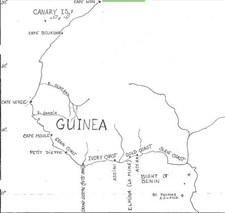
Although the naming of Sierra Leone is accorded to the Portuguese and later the British who formalised the name, it is the French [Normans] who can claim to have been the first Europeans in modern times to navigate these shores. A contemporary account of the voyages of discovery sponsored by Prince Henry the Navigator in the 15th century, reports the exploration, trading and settlement along the coast by sailors from Dieppe in the 14th century. Kaye Centers examines the evidence for these claims in her thesis, but sits on the fence, saying there is some evidence to support such claims, but not enough to be conclusive. The Normans claim to have settled at the places on this map: Petit Dieppe, Petit Paris, Assini, La Mina, Akra
However they appear to have sailed past Sierra Leone without landing.
One suggestion for the name Serra [saw] leone is that the mountains look like lion’s teeth. But I think this unlikely:


It would take a great deal of imagination to construe these mountains as lion’s teeth, unless a very old lion with worn out molars.
However, another theory put forward by Kamara and others for the reason behind the naming of Sierra Leone, is that the shape of the mountains from out at sea look like a lion and this combined with the sounds of thunder were the source of the name. I feel that this is more likely: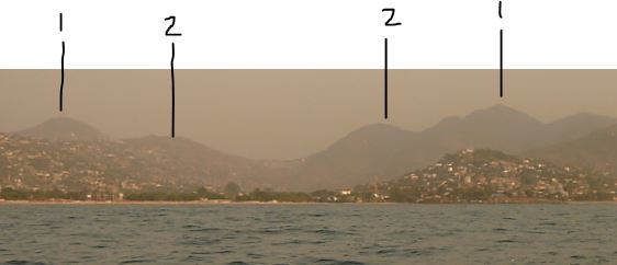
Sailors approaching land are likely to ‘see’ shapes in outline and these are at least as good as other ‘Lion Mountains’ around the world, for example Lion Head, Cape Town, which I could never quite make out.
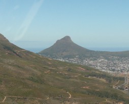
Lion Head, Cape Town
So although I cannot point to strong historical evidence for this theory, I can show why it has credence. Perhaps the roaring was added to give more authenticity and colour to the tale.
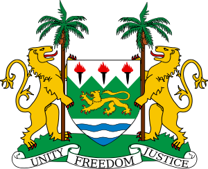
I have found no source showing that lions were ever found here. Leopards are certainly mentioned and as forest dwelling animals are more likely. All early descriptions of the country say it was forested, which as far as I’m aware is not the natural habitat of lions. Whatever the reason for the original name, it has stuck and the lion has been adopted for the coat of arms of the country. If you have any other theories to share, please leave a comment.
Update: I just came across another supporter of the lioness shape theory; non other than the polyglot explorer Richard Burton who visited Sierra Leone in 1882 and reported the following:
“The reason is disputed; some invoke the presence of the Queen of the Cats, others the leonine rumbling of the re-echoed thunder. The latter suggested the Montes Claros of the Portuguese. Cà da Mosto in 1505 tells us that the explorers ’gave the name of Sierra Leone to the mountain on account of the roaring of thunder heard from the top, which is always buried in clouds.’ But the traveller, entering the roadstead, may see in the outline of Leicester Cone a fashion of maneless lion or lioness couchant with averted head, the dexter paw protruding in the shape of a ground-bulge and the contour of the back and crupper tapering off north-eastwards. At any rate, it is as fair a resemblance as the French lion of Bastia and the British lion of ’Gib.’ Meanwhile those marvellous beings the ’mammies’ call ’the city’ ’Sillyown,’ and the pretty, naughty mulatto lady married to the Missing Link termed it ’Sa Leone.’ I shall therefore cleave to the latter, despite ’Mammy Gumbo’s’ box inscribed ’Sa leone.’”

The usual reason to visit Kent is to catch a boat to the Banana Islands, about half an hour away, but we decided to have a look around the village’s historic sites.
Our first impression of the village was not the best as we parked beside an earthen football pitch, strewn with plastic debris. Some men loitering nearby became a little belligerent when we said we just wanted to walk around the village, but later were more amenable and offered to show us around.
Boats are launched from both sides of a sandy isthmus which joins the village to a rocky outcrop. Fishermen were busy mending their nets. The Banana Islands floated hazily on the distant horizon.
")
")
From the fishing port, a sweep of pristine sand curves towards the hills. This beautiful beach was deserted. The lack of facilities and lack of any road direct to the beach must deter visitors, although there are a couple of resorts at the far end. The superstitious might be put off by the presence of a graveyard just behind the beach. A beautiful location to be laid to rest, marred slightly by the ubiquitous plastic debris blowing around behind the beach. Men were clearing the beach, but seemed to dump their collection behind the sand.


Between the village and the fishing port is the remains of the old slave baracoon, marked by a laterite wall, in places being absorbed back to nature. In the middle is the current primary school built directly on what was the holding pen for slaves – now only visible through small slits which allowed a minimum of fresh air into the space (the black section of the wall). The small door was barred and locked, but it was obvious that the height of the inner chamber was less than an adult would need to stand. The quarters above, now replaced, were used by the slave traders.


Back in the village we were shown other remains of old buildings used by slave traders, who collected slaves from the interior here, before transferring them to the Banana Islands or other trading points such as Bunce Island where they would be loaded on ocean going vessels to cross the Atlantic.


Down a track, to another part of the shore we found an abandoned sea-pool and derelict house. This was the seaside home of Siaka Stevens, former president.


The Stevens family still owns the site and a building next door, which was at one time a library, but is being renovated as a private house.
The church service was in full swing as we passed by and the two policemen on duty at the old colonial police station were busy doing their washing.


So, having thanked our guide we left Kent content that we had seen the historic sites. We returned past Burreh beach to the less visited John Obey. Here at Tribewanted, we ordered lunch then walked the length of the approximately 2km pristine beach, which is backed by a large lagoon preventing access from the peninsula road. At the far end of the beach a private dwelling has the only other access to the road.


Tribewanted aims to develop sustainable tourism in cooperation with local communities. Guests stay and get involved in building the sustainable infrastructure. Here at John Obey, one of the projects was the adobe houses inspired by CalEarth made from local materials and designed to have natural air conditioning with intakes low down on the walls and outlets high up (using the principle of warm air rising).

We went into the larger dome (not pictured) and found, in the middle of the day, it was indeed cool inside. There are also two wooden huts for rent, with bucket showers. The toilets on site are composting in line with the sustainable ethos.
Our lunch of grilled fish, chipped sweet potato and papaya was served overlooking the sea at a shady table. Nearby hammocks swayed in the breeze. It’s certainly a peaceful spot in which to chill for a few hours or indeed to stay overnight.